|
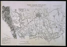
A Diagram of the Trench system, produced by the War office 1915
|
1 What were the key features of the trench system?
One key feature of the trench system was the frontline trench. This was the first trench in the system as it is just behind no-man’s-land. It was used as the firing line, where soldiers would stand up on the firing step, lean on the elbow rest and then fire at the enemy. In addition, this was the section from which they would go over the top and attack the enemy, when given the orders. A second key feature of the trench system was the support trench system. This is located from around 80 meters behind the front line, including the support, reserve and communication trenches. This sophisticated system could provide safety as it is away from the firing and troops could retreat. In addition, it can provide the front line with resources such as food, water, ammunition and information. |
2a How useful is Source A useful for an enquiry into an understanding of the trench system at the Western Front?
Source A is useful because it provides evidence about the overall structure of the trench system at the Western Front. It shows the geographical layout and location of the trenches when the map was made, in 1915. It provides insight because it was made by the army for the troops so it will be accurate and detailed because it was made for their own benefit and to inform themselves of the trench system. Its nature as a map, and purpose, to be used by troops, also indicates that it would be very accurate. They would have no reason to alter or incorrectly draw the diagram as it would just hinder themselves. In addition this diagram is the sixth revision meaning it is often updated and therefore it will provide accurate and detailed information about the trenches.
However, it does not provide a typical picture of this issue across the War. Because it was made in 1915 it does not provide information about the trench system from any time before or after this year. The map itself indicates that the layout of the trenches must have changed measurably between 1914-15, otherwise there would have been not need for 6 revisions of the map. We also know that there were significant developments in the war in 1916-17, with battles such as the Somme, Arras, Passchendaele and Cambrai. Therefore this source only proves a narrowed insight into1915.
Furthermore because of its nature as a map, Source A only provides evidence on the wider layout of the trenches and not internal features or the role of the trench system. This suggest that it may give an uncomprehensive portrayal of the trench system because the source was made for the troops who already know the internal details and features of the trenches.
Overall, Source A holds some utility for understanding the overall scale and format of the trenches, but lacks information on internal details and features.